This product is a high-precision integrated inertial navigation system, which integrates inertial platform and satellite navigation technology for vehicle environment. The system uses high-precision MEMS inertial devices and has the functions of inertial / Satellite / odometer integrated navigation, dual antenna orientation, RTK, zero speed correction, etc. it can realize high-precision real-time positioning and orientation at the same time. It can meet the needs of a variety of integrated navigation applications, especially suitable for the navigation of unmanned vehicles, UAVs, aircraft and other moving objects.
1.Brief Introduction
1.1 integrated navigation system (INS) is developed based on MEMS technology, with built-in positioning module and inertial measurement unit. The data fusion is realized by the built-in navigation computer, which can output real-time and accurate sensor data such as carrier attitude, orientation, position and speed.
2.Major Function
2.1 the main framework of the system (Integrated Navigation System) has the following hardware modules:
(1) The inertial measurement unit and the four frequency dual mode dual antenna satellite positioning board card.
(2) A pair of external multi-star and multi frequency GNSS antenna.
(3) Ins operation control unit.
(4) RTK communication (RS232 or Ethernet).
2.2 function description
(1) Positioning function: Based on MEMS technology, it can effectively solve the interruption and mutation of positioning results caused by satellite signal masking, and provide continuous, high-quality and high output positioning results.
(2) RTK: receive the satellite observation value and receive the information from the reference station, and calculate the RTK Positioning to achieve high-precision positioning of RTK and reach cm positioning accuracy.
(3) Inertial measurement: roll angle, pitch angle, azimuth, three axis acceleration and three axis angular velocity are obtained by IMU on board.
(4) Antenna calibration: according to the antenna and product location, calibration related data can achieve high-precision positioning.
(5) External communication: send processed data to bus through RS232, RS485, Ethernet or can communication.
(6) Data storage: ins can store antenna and position information configured by users, storage IMU calibration data, can message ID and other user information.
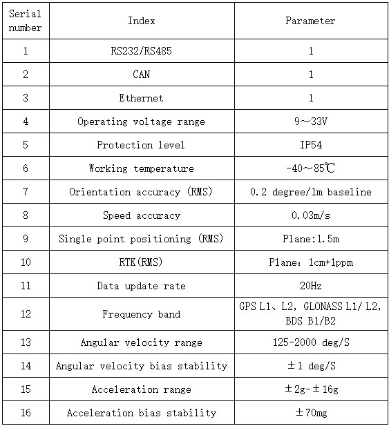
3.Technical Parameter


公司地址:天津西青中北镇开源路6号
版权所有:天津易鼎丰动力科技有限公司 ICP备案:津ICP备2021002978号 公安备案:12011102000438
